


British Columbia is located between the Pacific Ocean and the spectacular Rocky Mountains with an estimated population of 4.8 million people making it Canada's third most populous province. Explorations of Captain James Cook in 1778 and George Vancouver in 1792-93 established British jurisdiction over the northwest coastal region west of the Columbia River. Establishment of the trading posts under the auspices of the Hudson Bay Company established a permanent British presence. The first British settlement was Fort Victoria established in 1843 now the city of Victoria named after the British Queen of England remains the Province capital. On the mainland a short distance away from Vancouver Island the Colony of British Columbia was founded in 1858-66 by Richard Clement Moody being the Chief Commissioner of Lands & Works in response to the Frazer Canyon Gold Rush of the time where he was instructed 'to found a second England on the shores of the Pacific' and the English flavor still runs deep here today.

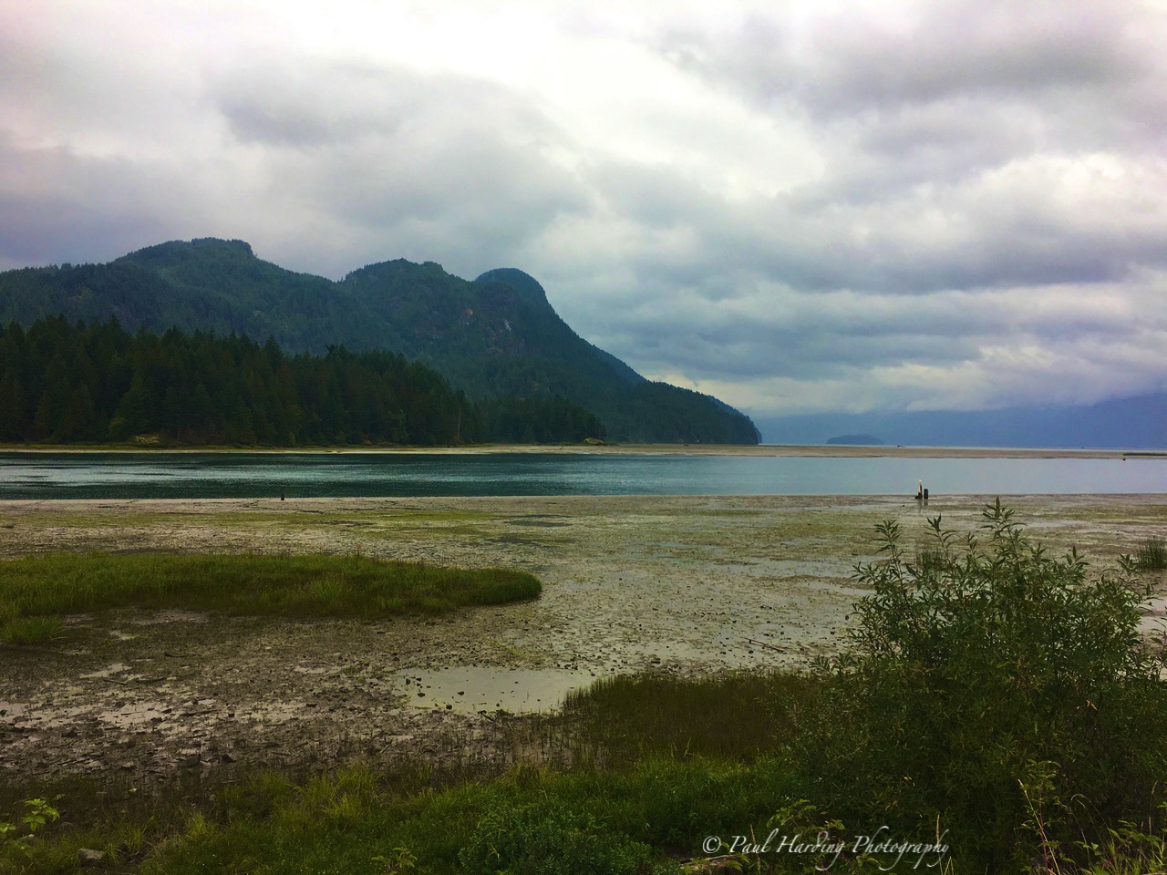
In 1862 the great Cariboo Gold Rush attracted an additional 5000 miners while Moody had selected the site for the 'secondary' capital of New Westminster establishing Cariboo Road and Stanley Park, where in September, as the leaves begin their fall colour change, we ride around absorbing the beauty found in the heart of Vancouver.


Our five mile drive around Stanley Parks' circumference offers thick tree lined roads, the drone of radial engines and departing flights of the seaplane base in the distance. British Columbia is all about seaplanes, here a leading source of transportation within the province with so many destinations unreachable by land or sea. Started decades ago by pioneering bush-pilots connecting the far out logging camps with civilisation.


The seaplane became the life-blood of the industries rugged existence. With logging and pulp mill closures the seaplane became a huge part of the tourism industry that became the mainstay for Canadian business that is today, catering to scenic flights, far out fish-camps and neighboring islands.


Here in Stanley Park aircraft afar are contrasted with totem poles of the First Nations including a famous stop for pictures of the ancient 'Hollow Tree'! A plaque teaches us the history of the totem and a collectors photograph portrays Chief White Hawk standing in the same position decades ago!


There are more than 200 First Nations within British Columbia with a significant number of indigenous languages. Early history passing by word of mouth along with early explorer accounts and archeological discoveries. Original nomadic arrivals are placed between 20,000 and 12,000 years ago, living in non-permeant structures foraging nuts and berries while hunting and trapping small game. As indigenous populations spread across vast territories they shared many traditions and customs.


British Columbia was divided by geographic region, the far northwest, the central inlands and fiord coastal. To the northwest of the province peoples include those who lived on the islands of southern Alaska and northern British
Columbia. The Na-Dene language group is believed to be linked to the languages of Siberia. Peoples who migrated across the far northern routes of Russia to Alaska and downward to British Columbia. The Dene of the western Arctic may represent a distinct wave of migration from Asia to North America. The interior lands of BC were home to the Salishan language groups and Athabaskan language groups. The inlets and valleys found sheltered large, distinctive populations sustained by the region's abundant salmon and shellfish. These peoples developed complex cultures dependent on the Western Red Cedar for construction of wooden houses, seagoing whaling and war canoes and elaborate carvings items and infamous totem poles.

As with much of the western exploration contact with Europeans brought a series of devastating epidemics of diseases to a people with no immunity, resulting in a dramatic population collapse; culminating in the 1862
Smallpox outbreak in Victoria that spread throughout the coast. European
settlement did not fare well for the remaining native population of
British Columbia. During the 1770s smallpox killed 30% of the Pacific northwest First Nations out done in 1862 with the Great Epidemic that further killed 50% of the remaining population, an estimated 60,000 people died along the coast in 1882.

Colonial officials deemed arrogantly that colonists could make
better use of the land than the First Nations people, and thus the land
territory be owned by the colonists.
To ensure colonists would be able to settle properly and make use of
the land, natives were relocated onto reserves, which were often too
small to support their way of life. By the 1930s, over 1500 reserves were located within British Columbia. (Re: Wikipedia)
We are here for near three weeks, enough time to barely scratch the surface exploring the neighbourhood of North Vancouver where we have found a fabulous B&B to stay. Set in a quiet old established neighbourhood where houses are picture-wise with groomed gardens display nothing but colour.


Our Canadian hosts point us in all the right directions, from exploring the city to wonderful nature walks through the wooded parks just minutes away from their location. British Columbia is all about nature, where their forest and woodlands offer remarkable countless hours of meandering intriguing bridged trails and gurgling streams.


Our exploration has us stumbling upon a picture perfect lake hidden within the trees. A wooden cottage at the far end decorates the setting used in many a film set, a large industry within the province, popular for escaping the expensive clutches of Hollywood. Sure enough we find a group of local artists capturing the idyllic scene on canvas.


Our first walks take us through about 4 miles of woodlands and out the far end into the the growing village of Edgemont with single main street lined with small shops and quaint coffee houses.


Our little home offers a perfect location to the Lions Gate Bridge taking us over to the city of Vancouver, to the north lies the famous Sea to Sky Highway. A magnificent 'must do' drive ending with a stay in Whistler Village that I had found some 30 years ago when first here, becoming our first adventure with an overnight stay.

By Arct - Own work, CC BY-SA 3.0, https://commons.wikimedia.org/w/index.php?curid=4400213
The drive northward to Whistler Village takes a little over an hour and a half. Try not stopping to photograph the beauty! The highway as we find it today begins in Horseshoe Bay, West Vancouver established as the start point in 1957. The original Highway 99 stretches 254 miles from the U.S. border northward and noted as the '5th most spectacular road trip in the world'! Built on the steep cliffs of Howe Sound the early road was simply two lanes with no barriers to the edge. Inclement weather and speeding took many drivers lives falling tragically far below. Major improvements began in the 1980s leading up to a finished four lane highway for the 2010 Winter Olympics. We find every excuse to pull over for a photograph as we enter the town of Squamish. Here the ride in a gondola to the top of the mountains is a must.

Located at the north end of Howe Sound, Squamish has a population just shy of 20,000 people having its beginning with the construction of the Pacific Eastern Railway in 1910. Forestry was the principal industry until the pulp operation ceased in 2006 with the sawmill and logging operations closing prior to this. Tourism became the mainstay of the local economy sporting over 300 climbing routes and hiking trails. The summer months support kiteboarding and windsurfing being a top location for western Canada. The famous Sea to Sky Gondola is found just off the highway before the town, we pull over and enjoy breakfast while the gondola starts its daily service to the top accommodating thousands on annual visitors.


Soon at the summit we find a full restaurant and shop facility where one spies the magnificent suspension bridge spanning the valley to the next peak. We venture across mesmerized by the panoramas on every side. There is no way one can simply walk across, everyone stops for that inevitable holiday keepsake photograph hundreds of feet above the forest floor with a skyline of gorgeous peaks as a backdrop.


On the other side we find a series of hiking pathways that lead into the conifer woodlands where again we stop to absorb and record the vistas while meeting many different nationalities, some of which we swap taking family portraits against the classic British Columbia scenery.


After leaving Squamish, we continue the beautiful drive for another 36 miles to find the world-renown ski town of Whistler, some 78 miles from our host city of North Vancouver. The resort lies between the Garibaldi and Pacific Ranges first surveyed by the British during the 1860s, naming the mountain London Mountain after the persistent fog that sometimes shrouded the peaks. Early human traffic in this very unforgiving area was sparsely frequented by cattle drivers from valleys and grazing to the north. A couple by the name of Myrtle and Alex Philip moved from Maine to Vancouver in 1910 after hearing rumor about the beauty of the area from Pemberton pioneer John Millar. They purchased 10 acres on Alta Lake establishing Rainbow Lodge later becoming part of British Columbia's first Resort Municipality in 1975. We drive through the entrance of the village now marked with a statue of the 2010 Olympic mascot named Illanaaq.


Our overnight stay here is at the Whistler Pinnacle Hotel, easily found at the edge of the main street running through the town. The first thing we notice is how pristine the village is, as remembered from my last visit here in the 1980s. Cloudless powder blue skies always help first impressions and certainly no sign of the 'London fog' the early surveyors witnessed.


Weaving our way through the village we come to the main square boasting totem poles and mementos of the 2010 Olympic Games held here. There is colour everywhere you turn, highlighted by rich maple trees turning their autumn splendor highlighting manicured hotels, shops, sporting goods stores and character coffee houses. Breakfast is served with rich steaming coffee and decadent pastries one fails to resist!


It was not until the 1960s when main utility infrastructure began to be laid, together with a road connecting Vancouver and Squamish. In 1962 four Vancouver businessmen explored the possibility of a ski resort with it in mind to bid for the 1968 Winter Olympics, an opportunity not considered by the Olympic Committee until decades later. Whistler mountain opened in 1966 to the general public.
Lying to the east of the village is the sister mountain of Blackcomb with an elevation of 7,992ft, topping Whistler by some 800ft, becoming part of the complete resort, its peak served by the Seventh Heaven lift facing Whistler Village. We are here in early autumn where mountain trail biking is the lead sport of this season.


We visit long time residents and friends from the first visit invited to dine that evening at one of their favourite restaurants where cuisine and service were delectable. The next morning offers an exploration of the entire village and a walk over to the Cultural Center of the First Nations on another pristine day. The scenery breathtaking and we need to photograph manicured gardens, intriguing bridges and flowing waters irresistible with a majestic Canadian mountain range as a backdrop, all suitable as postcards!


Returning to North Vancouver we decide it time to explore the city, braving traffic over the Lions Gate Bridge and into world famous Granville Market. We had both experienced this amazing place on past visits but not to repeat is a mistake! The city skyline with its modern glass structures are a vast contrast to the wild nature we so enjoyed being part of.


Granville Island is a peninsular across from Vancouver city center, once an industrial manufacturing area named after the 2nd Earl of Granville in 1915. In early times this was a fishing place for First Nations People spanning the inlet known as False Creek. The city originally had also been named Granville but renamed Vancouver in 1886. Wooden structures began the industrial complex and by 1923 every lot on the island was occupied. Between 1973 and 1982 the government invested some $24.7 million converting some 50,000 square feet into the Public Market.


Today's complex sees a farmers market, street artists, and day-vendors with about 50 permanent retailers spread over the 35 acre island. We explore inside the fruit and vegetable market, where those of us from simple tropical island markets are almost overwhelmed at the expanse of produce, making the displays a mind-blowing sight at far great a savings than we are used to paying!


Walking the many pathways around the island, looking back toward the city, we find wonderful shops varying from ships hardware to First Nations carvings. Choosing a restaurant was not a challenge although choice vast, settling finally on The Keg which proved a fabulous dining experience!


Residing on North Vancouver allowed us to have natural entertainment very close at hand. Time was of the essence so the choices came down to Grouse Mountain one day where the ladies challenged themselves one last time to complete the 'Grouse Grind'. The mountain itself exceeds 4000ft overlooking the city of Vancouver.

A popular ski resort in the winter months we find summer activities still in full swing with a wildlife sanctuary, chairlifts to the top and scores of hiking trails. The "Grind" is not for the faint of heart. Built in the 1980s and rebuilt again in the 90s as a 'conditioning trail'.


Melissa had tackled this before several years back, where on this completion declared "never again"! A steep rugged trail cut upward 2800ft, a distance of 1.8 miles with an average grade of 31% and 58% in places. The total number of 'stairs' totaling 2,830 had me far wiser choosing the gondola to the top!


At the summit I explore the terrain while the girls slog their way upward for 2hrs 5mins! Once together we dine in the restaurant on the apex of the first stage of the mountain with the city of Vancouver displayed far below. A chair lift takes us the rest of way upward to near 4000ft.


Near the summit we walk the hiking trails finding the wildlife sanctuary that had adopted two young grizzly bear cubs left without a mother; they had been an attraction here for years. Deer could be found grazing on the meadows unafraid of the general public that meandered through the woods and carvings that adorned the pathways.


From down at street level one can spy the blades of a huge wind turbine placed on the summit of Grouse Mountain. We walk around a forest pathway to come face on with the massive structure. The hub stands at 65 meters above the ground with a blade span of 76.8 meters producing 1.5 megawatts of power by sweeping an area of 4,657 square meters and weighing in at 250 tonnes!


While the gondola trip glides downward over the expanse of dense conifers, we plan a major hike the next day through the Capilano Forrest and over the famous suspension bridge to the far side of the gorgeous canyon.


Days in British Columbia are filled with outdoor adventure. The province displaying countless scenes of stunning beauty where disappearing into the depths of a forest becomes a must for us both. BC here is about trees and what the creative folks in the park services have done to allow us an in-depth enjoyment I have not found anywhere else.

Our next adventure will satisfy the thirst we have to learn about the magnificent wooden monoliths that soar from the forest floor, giant Douglas Fir, Red Cedar and Hemlock.

Capilano Regional Park is one on the twenty-one parks operated by Metro Vancouver featuring the Capilano Suspension Bridge, The Cliff Walk, the Capilano River & Lake being one of three major watersheds supplying 40% of the regions water supply. Visitors are greeted inside the entrance with more First Nation totem poles. Upstream lies the Cleveland Dam where 500 meters downstream features a fish hatchery with educational history of the salmon and a cross section of the active fish ladder.


Capilano Suspension Bridge is 460 feet long and 230 feet above the river below. A private facility attracting over 800,000 visitors from all over the world annually. The bridge originally constructed by Scottish Civil Engineer George Mackay in 1889, made with hemp rope and cedar decking, replaced with a wire cable in 1903 and refurbished completely once more in 1956; a photo of Melissa's mother taken maybe not far off this date with one of daughter recorded near the same place on the bridge just weeks ago here in 2017!


The bridge was sold to its current owner, Nancy Stibbard, CEO of the Capilano Group employing 450 people between the bridge, Stanley Park Pavilion and Vancouvers' Prospect Point. She had worked at Capilano during grade school and university after her father, Rae Mitchell, had purchased the location in 1953. Not imagining the venture leaving the family she took over the company with a huge bank loan later becoming a Canadian tourism award winner.

In 2004 the additional attraction of Treetops Adventures was added to the park. Here seven footbridges are suspended between giant Douglas Fir trees over on the west side of the canyon forming a walkway 98ft above the forest floor.


The Cliff Walk is not for the feint of heart or fear of heights! In June of 2011 the narrow steel structure clinging to the edge of the canyon cliff was an added attraction. An impressive structure just wide enough for a single-line of guests to walk around the cliff face suspended by steel implants into the rock face now suspending the structure near 100ft above the valley floor below.


Our stay draws to a close with a couple days left leaving our North Vancouver hideaway to stay with life-long friends, the Hyatt family, living in Port Coquitlam, once residents in the Bahamas. Our drive takes us through Port Moody and experiencing the new bridges on this far side of Vancouver.


Our last days are kindly guided by the family first for a nature walk around the area of Pitt Lake, the second largest lake in the lower mainland of British Columbia, 25km long and about 53.5 square kilometers in area. It is one of the worlds few tidal lakes, where here the average tide reaches some 3 feet separated from sea level. We walk through Pitt Meadows occupying the marshy southern end of the lake just southwest of Port Coquitlam.


The lake although prone to heavy winds and rain due to its great depth, is a very popular spot for canoeists and boaters where the waterfront and shore are for public access. The valley upstream from the lake known as Upper Pitt renown for is fly-fishing and steelhead streams.


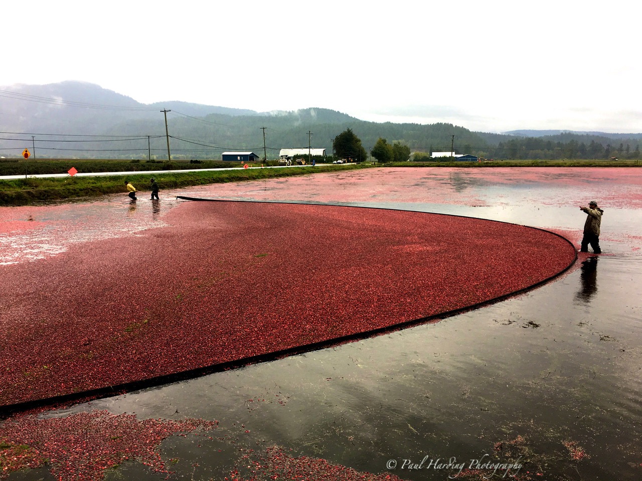
October is cranberry harvest in Pitt Meadows and as luck would have it, we stumble across a cranberry bog already filled with water allowing the fruits to float on the surface where they are netted for collection. The harvest is slightly early and we find men wading the bog with a huge net hauling by hand more usually done with machinery.


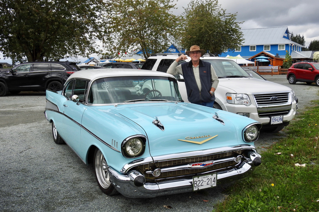
Our hosts had one more fun day planned before we leave for home in the Bahamas. Nestled in the middle of 200 acres in Langley, BC they take us to Krause Farm & Winery Estate. Seasonal fruit is there for your picking. This late September many of the fields have come to their seasonal end but our timing for fresh blackberries is spot on! The estate is a mass of ripe pumpkins readying for the fall Thanksgiving Holiday and classic cars found in the carpark complete the scene.


We walk past empty strawberry fields with baskets in hand where the four of us venture through the mass of blackberry vines. One fruit for the basket and maybe two or three for the tasting, gathering over 5 pounds in less than 30 minutes!


Krause Farms are famous for their fruit pies and fresh waffle breakfasts. Our hosts insist on destroying all hope of any diet, treating us to a Canadian food display beyond decadent!


While the ladies explored the country store Martin and I venture into the winery to find the barstools made from saddles, complete with a classic western barman called Ted tempting us to a glass or three of Mulled Wine that had been steeping from early morning.


The warm welcome liquid slid down easily as we all caught up on all our family stories since last together over 30 years ago! Tomorrow we fly home and on leaving the farm spy rows of young Christmas trees, the season is near upon us.

Our holiday is near concluded leaving memories of stunning scenery, of mountain ranges, dense forest and magnificent trees, racing rivers and still waters, welcoming townships, a vibrant city and fabulous people. One really should come and experience "Beautiful British Columbia" - a must see province in Northwest Canada, you will return, like us, more than once!

Stay with us on this Blog by clicking on "Follow by Email" at the top of each page, something new will come as a notification and by all means explore past adventures with a click on "Older Posts" at the bottom of each page. A 'Comment' below MOST welcome!
You have a real gift for photos Paul - balancing and framing pictures beautifully, with a natural eye for using light to capture vibrant colours.
ReplyDeleteThank you for the compliments Captain, appreciated!
Delete