UPDATE: Sept 7th, 2017
Hurricane "Irma" formed several days ago in the Atlantic Ocean, near the peak of hurricane season for this year. It's 11.40pm and 'she' is nearly upon us here in the capital already striking the southeast Bahama Islands with the strongest winds in the recorded history of storm meteorology, 185mph/297kmh sustained winds gusting 220mph. The islands further in the Caribbean have been devasted almost beyond recognition, some with 95% total destruction. It will take them years to heal.
(*NB: if you see a photo you admire, by all means click on to see an enlarged version to be dragged on to your desktop to keep!)
 Jost Van Dyke before "Irma"
https://www.facebook.com/NWSWPC/videos/1542182489181995/?hc_ref=ARQyP3q335RA8S7kwogaFI2ljJtxZwXUtb6awm37FIq0NFzFOjwQGje7U4g7hfAIWmQ
*(Cut & Paste to play)
The forecast track, however, seems favourable at the last minute for most of the central Bahamas, taking the 'eye' of the storm toward Cuba with a dramatic turn northward toward a strike on South Florida this Saturday and Sunday.
The winds are freshening here in Nassau as we see images from space of what could easily be termed 'The Perfect Storm". Tomorrow will bring near Tropical Storm winds to us with what will be a very fortunate near miss?
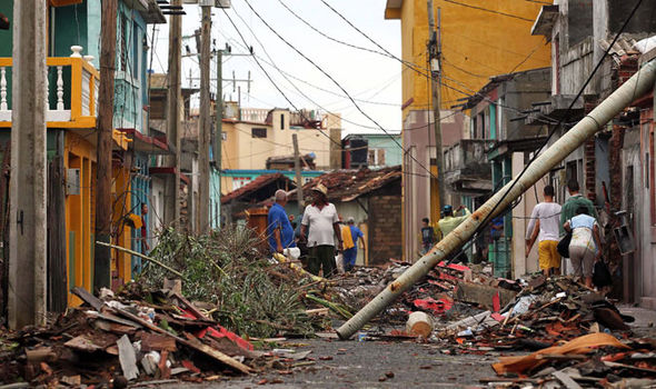
A "picture worth 1000 words" - here is an illustration of the destructive forces behind a 185mph sustained wind with gusts of 220mph on the island of St.Maarten.
Decades before modern weather forecasting every summer brought the foreboding phenomena of Hurricanes heading toward the Caribbean nations born as Tropical Storms off the African coastline. Today with amazing satellite technology we are able to actually see their long trek across the Atlantic Ocean.
Many storms make the journey across only to swerve northeastward to die in the cooler waters of the northern Atlantic, yet every hurricane season there are a few who fuel themselves in the warm summer oceans to enter the Caribbean Sea. From here they are influenced by pressure systems flowing across the American continent, some pushing them away some steering them between differing gradients of 'highs' and 'lows'. Forecasters with modern computer systems being able to predict their paths more often with considerable accuracy.
In centuries past many hurricanes in the West Indies were named after the particular saint's day on which the hurricane occurred; there was "Hurricane Santa Ana" striking Puerto Rico with exceptional force on July 26, 1825, and "San Felipe" repeated again hitting Puerto Rico on September 13 in both 1876 and 1928.
In 1953, the United States abandoned a confusing two-year old plan to name storms by a phonetic alphabet (Alpha, Bravo, Charlie) when a new, international alphabet was introduced using female names for storms. The practice changed in 1978 when men's and women's names were included in the Eastern North Pacific storm lists. In 1979, male and female names were included in lists for the Atlantic and Gulf of Mexico.
Each season a list of twenty-one names are selected by an international committee of the World Meteorolgical Organisation. The only time that there is a change is if a storm is so deadly or costly that the future use would be inappropriate for reasons of sensitivity and there are now about 80 names permanently 'retired' from the listing that started in 1953 through 2016.
Living here in the Bahama Islands all my life I have witnessed many storms first hand and have written in my published autobiography "Sharks in the Runway" (released in Spring 2017) about their formation, track toward us and when hit their awful devastation. Here are exerts from a chapter about Hurricane 'Donna' in 1960:
In late August, thousands of miles away the summer heat exploded upward above the African continent. Massive thunderstorms gathered above the hot landscape billowing majestically upward. Gentle offshore winds nudge the swirling mass of weather over the coastline into the warm waters of the tropical Atlantic Ocean. At the surface air pressure was falling and the thunderstorms were generating their own strong winds and heavy rainfall. The winds grow to sustain thirty-nine miles an hour across the oceans surface; a magic number for it is the season for monsters to be born.
Near the Cape Verde Islands off the African coastline the weather was explosive, climatic conditions conspiring to create a beast of nature that is unmatched in strength. A monster able to produce energy equivalent to seventy times the worlds total energy consumption, two hundred times the world’s electrical generating capability or plainly put, a ten mega-ton nuclear bomb! The hot summer sunshine forced the moist air to rise and condense as warm water vapour; a reaction creating incredible heat distributed also in upward direction, the temperature inside this swirling mass now much warmer than surrounding conditions outside. Enter the earth’s rotation and pressure gradient to start the mass turning counterclockwise. Nature has successfully manufactured its most deadly engine with the warm ocean waters as its fuel; winds begin to spiral around a tightening circle increasing velocity by the hour. The depression has grown into a tropical storm, the fourth disturbance this season carrying the ladies name ‘Donna’. From the beginning of record keeping storms carried girls names listed by the National Hurricane Centre in the United States, in later years by 1979 they alternated gender. Winds are speeding in greater velocity around the very middle of the system as the spiraling momentum increases, as if some monster is coiling itself to strike. The faster everything moves the more heat generated within, causing massive clouds to blossom dramatically upward thousands of feet above the surface, as high as an airliner flies; condensation gains pace, the natural engine sucking power from the warm saltwater it is racing over, as if an unstoppable runaway locomotive.
My father was a flight engineer with Bahamas Airways in 1960 and it became his responsibility to evacuate the airline fleet to safety where crews families were allowed seats onboard. We flew south of the predicted track of 'Donna' to Kingston, Jamaica. Our flight home is described in my book seeing the aerial views of islands appearing as if in a nuclear destruction. The storm hit with ferocity our southern islands in the archipelago continuing on to devastate the Florida Cays and mainland Florida exiting of the northern part of the state to travel along the Eastern Seaboard wreaking havoc to coastal communities battering as far as Rhode Island with 130 mph winds. A storm running damage costs in those days up to $400 million dollars!
During 'Donna' and 'Michele' that hit our Bahamas we would walk the neighborhoods to witness the destruction after being trapped indoors for hours listening to the wail outside, keeping a close watch for the approaching second half of the hurricane.
On September 2nd, 1999 a tropical wave moved off the African coast and five days later was named the eighth Tropical Depression 1000 miles east of the Lesser Antilles becoming Tropical Storm Floyd the next day. On September 11th (a date often common in hurricane history!) Floyd became a hurricane of 110 mph intensifying rapidly to 155 mph in just 24 hours due to very high ocean water temperatures in its path acting as fuel. The powerful storm remained just below a Category 5 (the most powerful on the Saffir-Simpson scale) as it clipped the outer islands of the Bahamas causing major damage to the large island of Abaco. Floyd was so large its outer bands touched the Carolinas in America to the north and near Cuba to the south with a huge center 'eye' 60 miles wide that would have engulfed the whole perimeter of Hurricane 'Andrew' that devastated some of our Bahamas and across south Florida in 1992.
The nearby countries of Central America and Mexico also face the threat of hurricanes each season fueled by their very warm ocean waters on their Pacific Ocean. On October 23rd, 2015 the National Hurricane Center showed sustained winds of 215 mph making it the strongest hurricane on record in either the eastern Pacific or Atlantic Ocean basins.
These ferocious hurricanes, the ones that reach the maximum scale strength, more often display the perfectly symmetrical 'Eye' in their center. An area of weather that when passing directly overhead creates a strange phenomenon of clear, bright blue weather only to see the second half of the storm bring the same ferocity from the opposite direction soon after. Hurricanes 'Isabel' and 'Joaquin' displayed this devastating behavior with only the latter storm hitting the southern Bahamas last year.
Both 'Joaquin' and 'Betsy' of 1965 hurricane season displayed a very rare behavior in their track. 'Betsy' passed our eastern most islands just far enough away from us to offer relief only to make a 180-degree turn during the night to return the next morning with a direct hit of 140 mph sustained winds over New Providence. 'Joaquin' showed even more bizarre track with its approach from the open Atlantic to directly devastate our southern islands of Long Island, Crooked Island and then immediately turn outward toward the open ocean again!
New wind flow technology displays the circulation of a hurricane beautifully. Winds coiling around the center eye-wall, coming from the east through north through west to southwest and south.
These southerly velocities act as a giant device pushing a wall of water onto the low-lying islands
creating 'Storm Surge' a force of destruction often more devastating than the very winds themselves.
With relentless constant force lasting hours, the seawater is 'pushed' onto the land during last years experience with 'Joaquin' and then again this year, 2016, with Hurricane 'Matthew'. Last year the outer islands received the full force to be left in tatters taking weeks to recover and repair.
Just a month ago Hurricane 'Matthew' became the 2nd major storm of the 2016 season, once reaching the eastern Caribbean, it became a hurricane and rapidly intensified. Its peak intensity was late Sept. 30 into early Oct. 1 when it reached Category 5 strength with 160 mph winds. We could see this powerful storm was going to possibly approach us from 'underneath', from the south. Hurricanes from here have historically hit us very hard and the path became incredibly evident.
'Matthew' made landfall in Haiti and eastern Cuba on Oct. 4 as a Category 4. This storm showed a form of 'intelligence' keeping it over open warm water and away from the mountainous regions of Hispaniola to its east and Cuba to the west, threading its way through the narrow channel between the two nations yet close enough for its eye wall to devastate both tips of each country.

As it passed through this region we suddenly saw the infra-red imagery from outer-space show an eerie picture depicting the face of a monster that was about to hit us with predicted 160 mph sustained winds hammering the Bahamas Oct. 5-6 as a Category 4 hurricane soon reaching near Category 5 as it hit Freeport, Grand Bahama.

As this monster crawled northward we started to feel its effects gaining wind velocity as the day progressed until Nassau experienced sustained winds of 140 mph for near six hours with much stronger gusts as images came in from Haiti losing over 1000 souls.

Forecasters correctly noted that a mere 20 miles difference in distance from its path would make a difference. The eye wall once again missed the mainland of New Providence and the largest island of our country Andros to the west. 'Matthew' threaded the narrow 28-mile gap slamming the western end of New Providence and northeastern side of Andros at the same time. The wind gauge at Templeton Weather Station in Lyford Cay broke with a gust of 165 mph and likewise over Freeport's International Airport with a velocity gust of 195 mph!
The only advantage to living in this region as far as storms are concerned is the modern weather technology that enables us to prepare days in advance! Unlike recent disaster this week in New Zealand with earthquakes where little or no warnings before the ground shakes and buildings collapse seeing the vast environmental damage that happened in seconds.
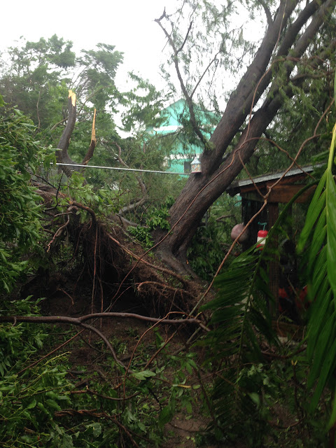
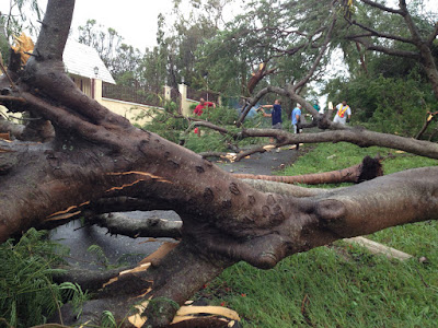
In the Caribbean, with risk as it is, we do have the luxury of warnings. Our building codes here in the Bahamas far out-weigh many structures throughout the Caribbean and our infrastructure often survive better than most. We lose electricity for days on end in hard hit regions; some fortunate to install generators and have underground wiring in select places for power and phone communication. Throughout 'Matthew' we were fortunate staying in touch with friends on the outside world reassuring our safety and sharing images with the power of the Internet. We walk the streets as always done after the wind subsides, to view gorgeous old trees destroyed and streets blocked. I photograph our little walkway before, during and after the storm. It takes three days to cut our way out in order to drive anywhere.
There is no one in the Capitol who escapes the wrath of this storm; in various degrees, our lovely world is devastated and takes weeks to clean up. There is a mile long swath of hurricane damage piled four stories high in our dump for waste in the center of New Providence, trucks wait in long lines loaded with cleaned up waste and debris.
The south shoreline communities of Coral Harbour, Adelaide Village and Lyford Cay lay in ruin although many buildings survive. It takes weeks to recuperate, the island noticeably bare of big trees and dense foliage. Mother Nature has thinned us out to take months of regrowth to come back slowly thanks to fresh water rains after the storm. The cost of this storm throughout the region estimated over $4 billion!
Gorgeous flowing Poinciana trees that blessed us this year with amazing blooms are largely gone now. A few hardy trees still stand although badly broken will return to bloom again next year? We see already one month later new beginnings of sprouting trees and shrubs, our island regrows, slowly. The ocean is clear again and we take on a better semblance of the paradise we know and love. There is a price to living here and fortunately, natural hardship comes rarely to these shores.
* NOTE: To receive updates on this Blog site click the"Follow by Email" link at the top of each page! - Comments are most welcome! Thank you for following our adventures in Paradise! ~ more to come!
"Sharks in the Runway," my autobiography, IS on now on sale in hardback, paperback or e-Book all found on Amazon.com sites in a country of your choice!


With the maximum that we get to understand and certainly making a mark would be helpful to us trip to niagara falls from nj is always a thing that brings the best to the learning it creates.
ReplyDelete